Ethiopia: A Land of Contrasts – The Geography That Shapes a Nation
Ethiopia, an ancient landlocked country in the Horn of Africa, is a place of stunning contrast and geographical wonder. From the lofty peaks of the Ethiopian Highlands to the searing heat of the Danakil Depression, Ethiopia’s diverse landscapes are as much a part of the country’s identity as its rich history and vibrant cultures. This dramatic variety in terrain has influenced not just the ecosystems but also the nation’s social, economic, and political life, creating a nation marked by resilience, adaptability, and pride.
The topography of Ethiopia is a testament to nature’s power, from lush highlands that have cradled ancient civilizations to arid deserts where human endurance is constantly tested. Understanding Ethiopia’s geography is key to understanding the people and the spirit of this remarkable land.
The Ethiopian Highlands: The Heart of the Nation
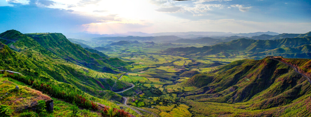
The Ethiopian Highlands are at the core of the country’s geography, stretching across much of the northern and central regions. These vast plateaus and rugged peaks are not just a physical feature—they represent the lifeblood of Ethiopia. The highlands are home to most of the country’s population and have played a central role in shaping its history, culture, and way of life.
A Cradle of Civilization
For thousands of years, the Ethiopian Highlands have been a center of civilization. The fertile volcanic soils support a variety of crops such as teff, barley, wheat, and coffee, and the highlands are often referred to as the “Cradle of Ethiopian civilization.” This region saw the rise of powerful empires such as the Axumite Empire, known for its monumental obelisks and as an early center of Christianity in Africa. The medieval Zagwe and Solomonic dynasties also emerged from the highlands, making it the heart of Ethiopia's historical and political life.
The Blue Nile: Ethiopia’s Lifeline
The highlands are cut by rivers, with the Blue Nile being one of the most significant. Originating from Lake Tana, Ethiopia’s largest lake, the Blue Nile flows through deep gorges before it joins the White Nile in Sudan. The Blue Nile is vital not only to Ethiopia’s agriculture but also to its geopolitical standing, as it contributes a significant portion of the Nile River's flow. The river has shaped both the landscape and the economy of the highlands for centuries.
A Temperate Climate in the Tropics
Ethiopia lies near the equator, yet its highlands benefit from a temperate climate due to their elevated altitude. While much of Africa experiences scorching heat, the Ethiopian Highlands enjoy moderate temperatures and regular rainfall. This makes the highlands ideal for agriculture and human habitation. The contrast between the cooler highlands and the hot lowlands is a striking feature of Ethiopia’s diverse climate.
The Simien Mountains: A Natural Wonder
The Simien Mountains are one of the most breathtaking parts of the Ethiopian Highlands. A UNESCO World Heritage Site, this mountain range is home to jagged peaks, deep gorges, and unique wildlife such as the Gelada baboon, Walia ibex, and the Ethiopian wolf. Ras Dashen, Ethiopia’s highest peak at 4,550 meters (14,928 feet), towers over the landscape, making the Simien Mountains a top destination for adventurers and nature lovers.
The Danakil Depression: One of the Hottest Places on Earth
While the highlands provide a temperate climate, the Danakil Depression , located in northeastern Ethiopia in the Afar region, is one of the most extreme environments on the planet. This desert region is an alien landscape where extreme heat and geological activity combine to create a surreal and sometimes hazardous environment.
A Harsh, Otherworldly Landscape
At 125 meters (410 feet) below sea level, the Danakil Depression is one of the lowest and hottest places on Earth. Temperatures regularly exceed 50°C (122°F), and the region is home to salt flats, lava fields, and active geothermal springs. This hotbed of geological activity makes the Danakil Depression one of the most geologically dynamic areas in the world.
Key Features of the Danakil Depression
- Dallol Sulfur Springs – A landscape of vibrant mineral deposits in neon green, yellow, and orange, formed by intense geothermal activity.
- Erta Ale Volcano – A rare active lava lake, often referred to as the "Gateway to Hell" due to its constant bubbling lava.
- Salt Flats and Mining – For centuries, the Afar people have mined salt in this region, transporting large slabs of salt by camel caravans across the harsh desert.
Despite its extreme conditions, the Danakil Depression is home to resilient Afar communities, who have adapted to its challenges by developing unique ways of life suited to the harsh environment.
The Rift Valley: Ethiopia’s Geological Backbone
The Great Rift Valley runs through Ethiopia, dividing the highlands and creating a geological wonderland. The Rift Valley stretches from the Middle East to Mozambique, and in Ethiopia, it is home to an array of volcanic formations, lakes, and fertile plains.
Lakes and Biodiversity
The Ethiopian Rift Valley is rich in biodiversity, with numerous lakes that provide essential water sources for both wildlife and human settlements. Some of the most notable lakes include:
- Lake Tana – Ethiopia’s largest lake and the source of the Blue Nile.
- Lake Awasa, Lake Ziway, and Lake Abaya – These freshwater lakes support fishing, agriculture, and tourism.
- Lake Abbe – Known for its eerie limestone chimneys and hot springs, located near the Djibouti border.
The Rift Valley is also home to a variety of wildlife, including hippos, crocodiles, and a wealth of bird species, making it a hotspot for eco‑tourism and conservation.
The Lowlands: Arid Deserts and Vast Grasslands
In stark contrast to the fertile highlands, Ethiopia’s lowland regions include arid deserts and vast grasslands, each with its own unique challenges and beauty.
The Ogaden: Ethiopia’s Dry Frontier
The Ogaden region , located in southeastern Ethiopia, is a semi‑arid desert. With dry riverbeds and scrubland dominated by acacia trees, the Ogaden is home to Somali pastoralist communities who have long relied on livestock herding as their primary livelihood. This region is strategically important due to its proximity to Somalia and its rich natural resources, including potential natural gas reserves.
The Western Lowlands: Ethiopia’s Agricultural Future
In contrast to the dry eastern lowlands, the western lowlands—bordering Sudan and South Sudan—are fertile grasslands that receive more rainfall. These areas support large‑scale farming of sorghum, sesame, and maize, and are home to Ethiopia’s wild coffee forests, particularly in regions such as Gambella and Kaffa. The western lowlands represent the agricultural future of Ethiopia, with their potential to support both local communities and broader economic growth.
5. Ethiopia’s Rivers: Lifelines of the Nation
Ethiopia’s rivers play a pivotal role in shaping the country’s economy and supporting its agricultural industry. The country’s mountainous terrain gives rise to several major rivers, with the Blue Nile being the most significant.
Major Rivers of Ethiopia
- The Blue Nile River – Originating from Lake Tana, the Blue Nile flows for over 1,450 kilometers, eventually joining the White Nile in Sudan to form the mighty Nile River. The Blue Nile is vital not only for Ethiopia’s agriculture but also for regional geopolitics, as it is the primary source of water for Egypt and Sudan.
- The Awash River – Essential for irrigation and a key water source for Ethiopia's lowland regions, the Awash River provides vital resources for agriculture and sustains ecosystems in the eastern part of the country.
- The Omo River – Flowing southward into Lake Turkana, the Omo River is crucial for the communities living along its banks and supports a rich biodiversity, including numerous species of fish, birds, and mammals.
In recent years, Ethiopia has invested heavily in hydroelectric power, with the Grand Ethiopian Renaissance Dam (GERD) standing as a monumental achievement. This dam will provide sustainable energy to Ethiopia and the broader region, transforming the country’s energy infrastructure.
Conclusion: Ethiopia’s Geographic Diversity Shapes Its Identity
Ethiopia’s geography is more than just a collection of landscapes; it is a defining force that has shaped the country’s identity. From the towering peaks of the Simien Mountains to the barren salt flats of the Danakil Depression, Ethiopia’s diverse terrain influences its agriculture, economy, and culture in profound ways. The country’s people have adapted to the challenges of their environment, creating a society that thrives in both the cool highlands and the scorching lowlands.
The geographic tapestry of Ethiopia is not only visually stunning but also a testament to the resilience and resourcefulness of its people. Whether trekking through the rugged mountains, exploring the volcanic Rift Valley, or witnessing the unique cultures of the western lowlands, Ethiopia’s landscapes offer a journey of discovery, wonder, and awe.