Ethiopia: A Geographic Tapestry of Diverse Landscapes and Natural Wonders
Ethiopia, often celebrated as the "Roof of Africa" , is a land of striking contrasts, where towering mountain ranges, expansive deserts, and lush valleys blend together into a stunning display of natural diversity. Unlike many countries with uniform geographical features, Ethiopia offers a wide array of landscapes that each contribute to the country’s unique identity. From the cool highlands that have nurtured ancient civilizations to the harsh lowlands that challenge both flora and fauna, Ethiopia’s geography plays an integral role in shaping its culture, history, and way of life.
The varied landscapes of Ethiopia don’t just serve as scenic backdrops; they actively influence the livelihoods of its people. Agriculture, economy, settlement patterns, and even cultural traditions are all deeply intertwined with the land. Whether it’s the fertile highlands that sustain agriculture or the remote deserts that push the limits of human endurance, Ethiopia’s geography is an essential key to understanding the soul of this ancient land.
1. The Ethiopian Highlands: The Cradle of Civilization
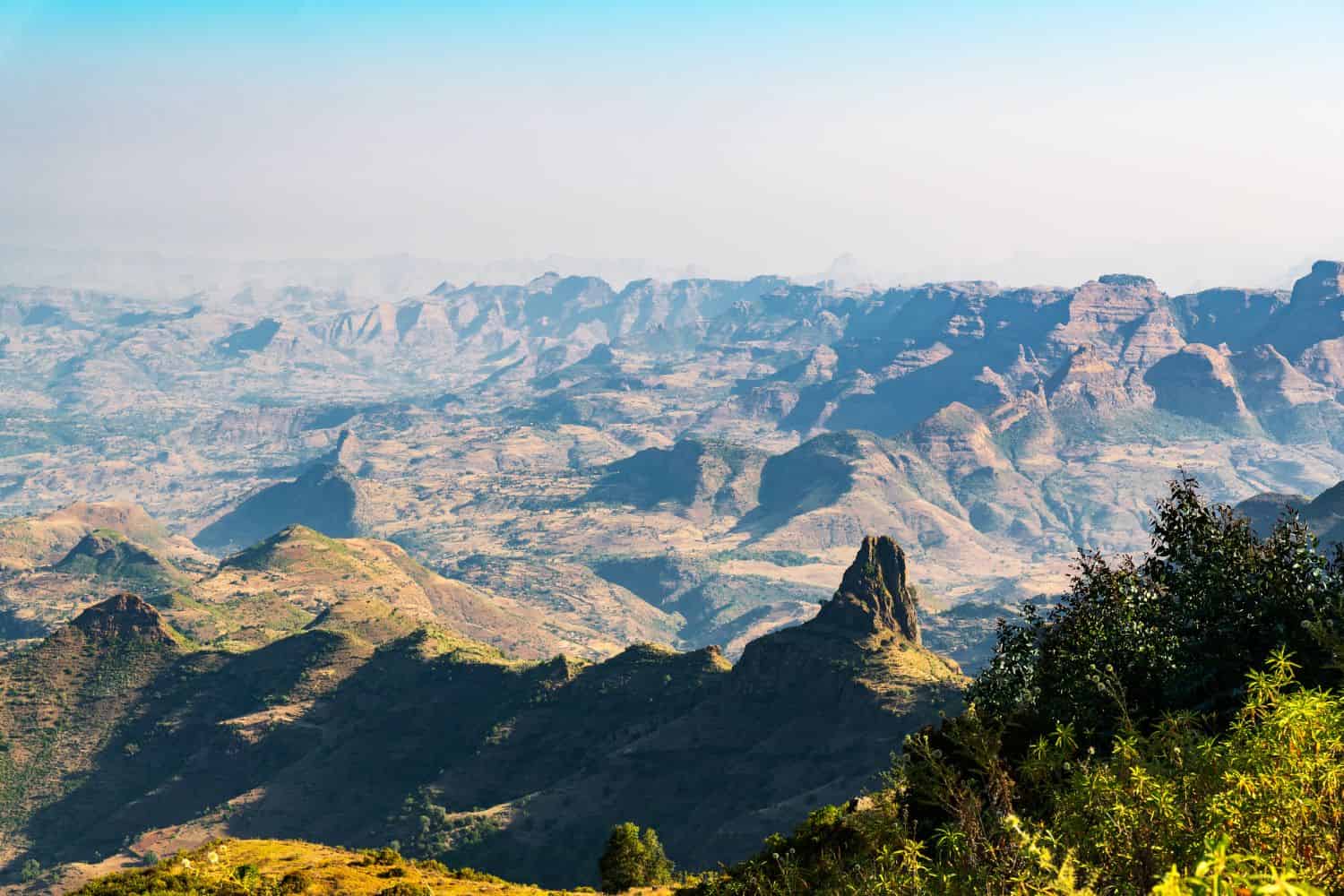
The Ethiopian Highlands , often referred to as the "Roof of Africa," form the heart and soul of the country. This vast plateau, covering much of central and northern Ethiopia, is one of the most significant highland regions in Africa, with an average elevation exceeding 2,000 meters (6,500 feet). The dramatic peaks, deep valleys, and fertile farmland of the Ethiopian Highlands have long been home to some of the world's earliest and most advanced civilizations.
Key Features of the Highlands
- The Simien Mountains National Park – A UNESCO World Heritage Site, the Simien Mountains are a treasure trove of natural beauty, with jagged peaks, expansive valleys, and rare wildlife species such as the Gelada baboon , the Ethiopian wolf , and the Walia ibex. The Simien Mountains offer breathtaking views and a pristine wilderness perfect for adventurers and nature lovers.
- Ras Dashen – Standing at 4,550 meters (14,928 feet), Ras Dashen is Ethiopia's highest peak and is part of the Simien Mountain range. This towering summit is a favorite destination for mountaineers and trekkers, offering stunning vistas and the challenge of navigating some of the most rugged terrain in Africa.
- Lalibela and Axum – The cities of Lalibela and Axum, both situated in the highlands, are steeped in Ethiopia’s ancient history. Lalibela is famous for its rock‑hewn churches, carved out of solid stone during the reign of King Lalibela in the 12th century, while Axum is renowned for its towering obelisks and its role as the center of the ancient Axumite Empire, considered one of the greatest civilizations in Africa.
Climate and Agriculture in the Highlands
The climate in the highlands is typically temperate, with cooler temperatures and abundant rainfall, making it ideal for farming. This region is the breadbasket of Ethiopia, with crops like teff (used to make the traditional injera), barley, wheat, and coffee growing in abundance. The fertile soils and favorable climate have allowed civilizations to flourish in the highlands for millennia. The highlands are not just important for their agricultural output but also for their role in sustaining the cultural and historical legacy of Ethiopia’s ancient kingdoms, such as the Axumite and Zagwe dynasties.
2. The Great Rift Valley: A Geological Wonder
One of the most impressive natural features of Ethiopia is its part of the Great Rift Valley, a massive geological fissure that stretches from the Middle East down through East Africa. In Ethiopia, this rift divides the highlands and creates a varied landscape of lakes, volcanic formations, and lush plains.
Lakes of the Rift Valley
Ethiopia’s section of the Great Rift Valley is home to a number of interconnected lakes, each with its own unique role in the country’s ecology and economy. These lakes are vital for local agriculture, wildlife, and human settlements:
- Lake Tana – As Ethiopia’s largest lake, Lake Tana is the source of the Blue Nile, and plays a crucial role in the country’s water system and agriculture. The lake is also central to Ethiopian history and culture, with monasteries dotting its shores, many of which date back to the medieval period.
- Lake Awasa, Lake Ziway, and Lake Abaya – These Rift Valley lakes are important for both local agriculture and tourism. They are teeming with birdlife, making them popular spots for birdwatching, while also providing livelihoods for those who rely on fishing.
- Lake Abbe – This surreal lake, located near the Djibouti border, features bizarre limestone formations and active geothermal features, giving the landscape an almost alien appearance.
Volcanic Activity and Hot Springs
The Rift Valley is known for its volcanic activity, which adds another fascinating layer to the region’s landscape. Erta Ale , one of the world’s most active volcanoes, houses a permanent lava lake that offers a rare and dramatic glimpse into the Earth’s molten interior. The surrounding region is dotted with hot springs and sulfuric formations, making it a unique and otherworldly place. These volcanic landscapes are not only visually striking but also serve as a reminder of the powerful geological forces that shape Ethiopia.
3. The Danakil Depression: One of the Hottest and Lowest Places on Earth
In stark contrast to the cool highlands, the Danakil Depression , located in the northeastern Afar region, is one of the hottest and lowest places on Earth. Sitting at over 125 meters (410 feet) below sea level, this arid region is infamous for its scorching temperatures, which often exceed 50°C (122°F), making it a truly inhospitable environment.
Key Features of the Danakil Depression
- The Dallol Sulfur Springs – The Dallol region is home to vibrant, neon-colored sulfur springs, creating a surreal, almost alien landscape. The mineral deposits formed by volcanic and hydrothermal activity give the area its otherworldly appearance.
- Salt Flats and Salt Mining – The salt flats of the Danakil Depression are vast and striking, and have been mined for centuries by the Afar people, who extract the valuable "white gold" to sell and trade. The salt is still transported across harsh desert terrain using camel caravans, maintaining a centuries‑old tradition.
- Active Volcanoes – Erta Ale, known as the "Gateway to Hell," is an active shield volcano with a permanent lava lake. It is one of the few volcanoes in the world that has such an extraordinary feature, attracting both geologists and daring adventurers.
Despite the extreme conditions, the Danakil Depression supports resilient communities who have adapted to the harsh climate over generations, and the region continues to be a significant point of interest for scientific research into Earth's geology and extreme environments.
4. The Western Lowlands: Fertile Grasslands and River Valleys
The western lowlands , bordering Sudan and South Sudan, offer a stark contrast to the arid landscapes of the Danakil Depression. This region is defined by rolling savannas, fertile river valleys, and dense forests that receive substantial rainfall, creating a lush and vibrant landscape.
Key Features of the Western Lowlands
- The Gambella Region – Known for its expansive wetlands and incredible biodiversity, Gambella is home to some of Africa’s largest wildlife migrations, particularly the Nile lechwe, a rare and endangered species.
- The Blue Nile Gorge – Often compared to the Grand Canyon for its dramatic landscape, the Blue Nile Gorge is a deep, narrow canyon carved by the Blue Nile River. The gorge’s stunning views make it one of Ethiopia’s most breathtaking natural wonders.
- Coffee Plantations – The western highlands, including the Kaffa region, are home to Ethiopia’s famous wild coffee forests, where coffee beans grow naturally and are harvested using traditional methods.
The western lowlands are also crucial for Ethiopia’s agricultural output, producing staple crops such as sesame, sorghum, and maize, as well as supporting nomadic pastoralists who rely on the land for grazing.
5. Ethiopia’s Rivers: Lifelines of the Nation
Ethiopia’s rivers play a pivotal role in shaping the country’s economy and supporting its agricultural industry. The country’s mountainous terrain gives rise to several major rivers, with the Blue Nile being the most significant.
Major Rivers of Ethiopia
- The Blue Nile River – Originating from Lake Tana, the Blue Nile flows for over 1,450 kilometers, eventually joining the White Nile in Sudan to form the mighty Nile River. The Blue Nile is vital not only for Ethiopia’s agriculture but also for regional geopolitics, as it is the primary source of water for Egypt and Sudan.
- The Awash River – Essential for irrigation and a key water source for Ethiopia's lowland regions, the Awash River provides vital resources for agriculture and sustains ecosystems in the eastern part of the country.
- The Omo River – Flowing southward into Lake Turkana, the Omo River is crucial for the communities living along its banks and supports a rich biodiversity, including numerous species of fish, birds, and mammals.
In recent years, Ethiopia has invested heavily in hydroelectric power, with the Grand Ethiopian Renaissance Dam (GERD) standing as a monumental achievement. This dam will provide sustainable energy to Ethiopia and the broader region, transforming the country’s energy infrastructure.
Conclusion: Ethiopia’s Geographic Diversity Shapes Its Identity
Ethiopia’s geography is more than just a collection of landscapes; it is a defining force that has shaped the country’s identity. From the towering peaks of the Simien Mountains to the barren salt flats of the Danakil Depression, Ethiopia’s diverse terrain influences its agriculture, economy, and culture in profound ways. The country’s people have adapted to the challenges of their environment, creating a society that thrives in both the cool highlands and the scorching lowlands.
The geographic tapestry of Ethiopia is not only visually stunning but also a testament to the resilience and resourcefulness of its people. Whether trekking through the rugged mountains, exploring the volcanic Rift Valley, or witnessing the unique cultures of the western lowlands, Ethiopia’s landscapes offer a journey of discovery, wonder, and awe.